

- Tradeindia
- Educational Aids
- Geographical Chart
Geographical Chart
(24 products)
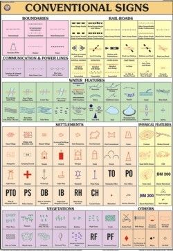
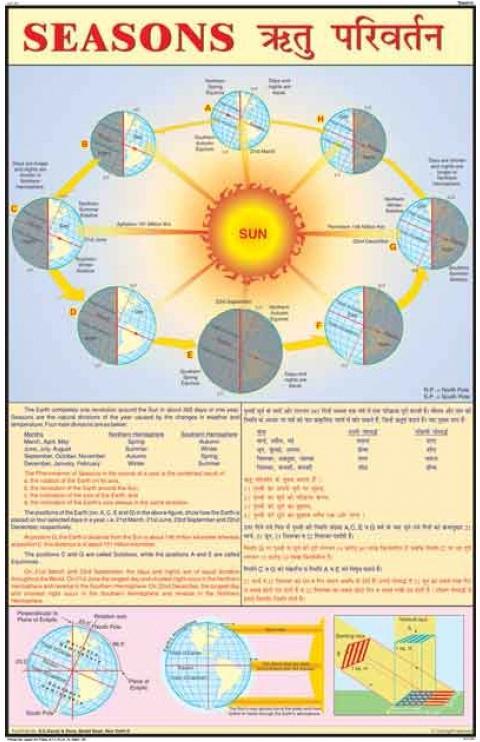
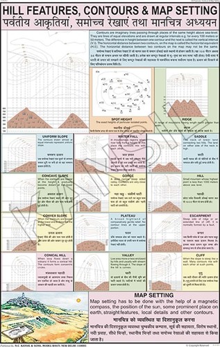
Conventional Signs Chart Equipment Materials: Printed On Synthetic Paper
MOQ1 Box/Boxes
Surface FinishGlossy
UseClassroom, Training, Reference
SizeStandard
StyleEducational Chart
AssemblyReady to use, No assembly required
FeaturesClear symbols, Laminated surface, Vivid graphics


Geography Lab Catalog - High Quality Material, White Color | Ideal for Educational Research Use
Price: 300.0 INR/Piece
MOQ1 Piece/Pieces
UsageEducational use
Product TypeGeography Lab Catalog
ColorWhite
ApplicationResearch

Leminated Charts labcare-Online
Price: 100 INR/Pack
MOQ5 Pack/Packs
Surface FinishGlossy laminated
FeaturesDurable waterproof easy to clean
Model NoLC-123
SizeStandard chart size
AssemblyPre-assembled laminated chart
WeightLightweight less than 200 grams
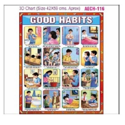
Chart Aech-116 - Assembly: No Assembly Required
Price: 50.00 INR/Piece
MOQ2 Piece/Pieces
Features3D design with clear illustrations
AssemblyNo assembly required
StyleIllustrative and educational
Surface FinishLaminated
UseHome schools daycares
Size42x69 cm
Geography Models - Laminated Thick Paper, 75x100 cm Rectangular | Wall Hanging Design for Schools and Colleges, Ideal for Lab and Ayurveda Use
Price: 1800 INR/Piece
MOQ1 Piece/Pieces
Stylerectangular
UseLab in school / Ayurveda
Materialthick paper laminaed
Dimensions75x100 Centimeter (cm)
Age5
Advantagewall hanging
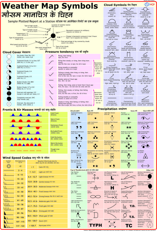
Weather Map Symbols Chart Dimensions: 70 X 100 Centimeter (Cm)
Price: 275 INR/Piece
MOQ25 Piece/Pieces
MaterialLaminated
Dimensions70 x 100 Centimeter (cm)
ShapeMulticolour

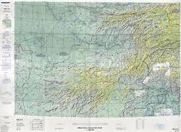
Operational Navigation Charts
ColorGreen
DimensionsVariable
FeaturesPrecise Navigation, Detailed Mapping, Safe Travel, Route Planning, Operational Use
MaterialPaper
Product TypeNavigation Chart
ProjectionUTM
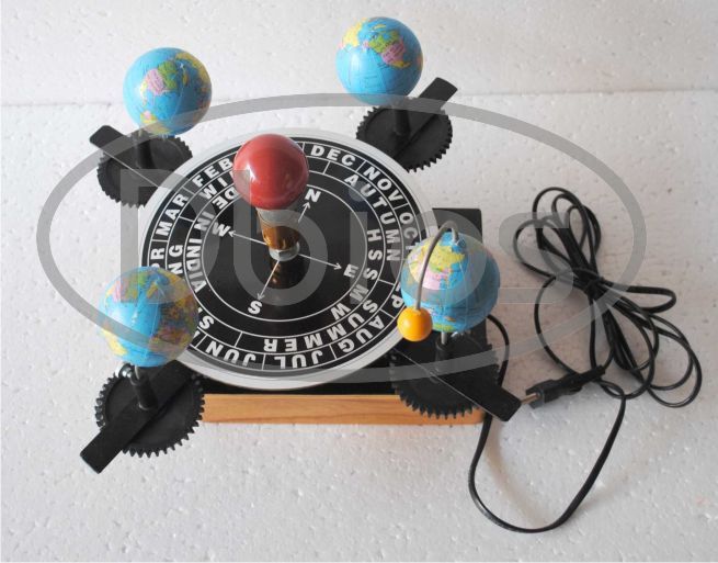
Geographical Model
AssemblyPre-Assembled
BaseStable
ComponentsVisible Parts
DiagramsLabeled
FeaturesEducational Tool, Durable Material, Visual Aid, Easy To Use, Clear Diagrams
MaterialHigh Quality
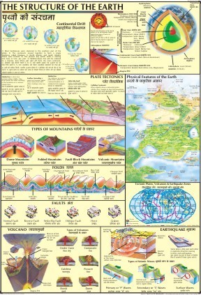
Chart Of Earth Structure
CertificationGovernment of India
ColorBeige
DimensionsVariable
FeaturesEducational tool, Detailed diagrams, Durable material, Waterproof, Government certified
MaterialPaper
PrintingDigital
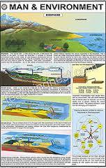
Man And Environment Charts
FeaturesEducational tool, Visual learning, Laminated film, Durable chart, Multiple languages
available_inEnglish/Hindi
film_thicknessThick
laminationBoth sides
language_optionsMulti-language
materialPlastic film

Fine Finish Soil Conservation Charts
CoverTransparent Plastic
Dimensions70cm x 50cm x 7cm
Features3D Model, Teaching Tool, Soil Conservation, Portable, Multipurpose
LanguagesEnglish/Hindi
MaterialPlastic, wood
TypeEducational Model
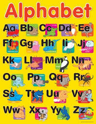
Teaching Charts
ColorYellow
Dimensions20x30 cm
FeaturesVisual learning, Alphabet teaching, Early education, Colorful design, Engaging content
FinishGlossy
MaterialPaper
Print TypeFull color
FAQs Related to Geographical Chart
Who are the top geographical chart manufacturers in India?
- N. C. Kansil & Sons
- Labcare Instruments & International Services
- K Rajan Industries
- Divyansh Educational & Laboratory Products
- Rx2 Sci-tech India
- G. D. Biological Model Works
- Mvl Instruments
Which cities have the largest number of geographical chart suppliers?
- Delhi
- Pune
- Kolkata
- Ambala
What is the price range for geographical chart offered by listed companies?
| Company Name | Currency | Product Name | Price |
|---|---|---|---|
| DESH BIOLOGICAL | INR | Geography Models | 1800 |
| K Rajan Industries | INR | CHART AECH-158 | 50 |
| LABCARE INSTRUMENTS & INTERNATIONAL SERVICES | INR | Leminated Charts labcare-Online | 100 |
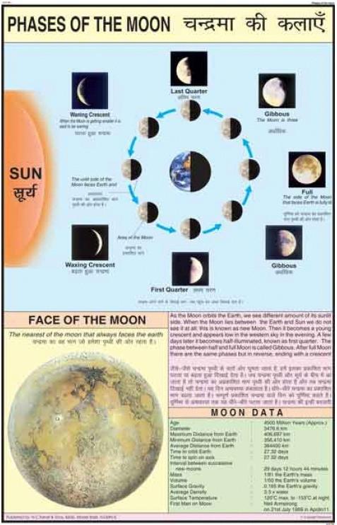
| VIDYA CHITR PRAKASHAN | INR | Phases of the Moon Chart | 275 |
How many trusted sellers are available for geographical chart?
- N. C. KANSIL & SONS
- RX2 SCI-TECH INDIA
- K Rajan Industries
- G. D. BIOLOGICAL MODEL WORKS
What is the minimum order quantity for geographical chart?
Do listed companies have registration & certifications?
- LABCARE INSTRUMENTS & INTERNATIONAL SERVICES
- K Rajan Industries
- LAB SECTION
- G. D. BIOLOGICAL MODEL WORKS
- DIVYANSH EDUCATIONAL & LABORATORY PRODUCTS
What is the get latest price feature?
What types of payment methods are accepted by the geographical chart suppliers?
Geographical charts are detailed maps of a particular area, the term "area" here encompasses all water bodies, land, atmosphere etc. Geographical charts are widely used for navigation purposes in ships, flights and by people who are out there to explore a certain geography and many more.
Geographical charts are designed in such a way so as to ensure these are easy to read and understand. Also, a greater care is accorded to make sure the proportional distances relative to the real distances are as precise as possible. It would also be safe to assume that these charts are an essential part of scientific research, oceanography, astronomy and many other sectors.
As mentioned above, geographical charts are of different types with various specifications; these are affordable and can be customized to some extent.
Benefits of Geographical Charts
Geographical charts provide a wide range of information that makes these useful to both professional as well as recreational chart users. Some benefits accorded by these charts are,
These help in planning of the route to be taken while reaching a destination
These provide accurate latitude and longitude figures
Detailed geographical charts also allow a navigator to give a sense of where he/she is vis-a-vis the international date line, thus enabling accurate time keeping
In case of any unforeseen situation, these can also help users reach the nearby safety and evacuation point
Geographical charts relating to astronomy have wide usage in calculating distances between different planets, stars etc.
How to Correctly Read a Geographical Chart
To optimally utilize a geographical chart, one needs to take care of the following aspects :
Choose the right chart i.e- the chart should conform to the geography of the place where one is hoping to utilize it.
To read a chart correctly one needs to understand compass directions, grid references and the map's key and scale.
Check the chart's orientation, most charts contain maps that are drawn with north located at the top.
Understand the scale of the chart. If the scale is 1:1000, then simply put, 1 unit in the chart is equal to 1000 units in real world.
Note the latitude and longitude.
Learn how to read contour lines. Contour lines indicate how high or flat the land area is.
Figure out the starting point and the destination on the chart before embarking on a journey and also plot the full route.
Client Testimonials & Reviews

Jayendrabhai
Elora Board Works
We are associated with tradeindia from last 1 year and this platform helped us to improve and grow our business. We are very thankful to tradeindia.com for its services and promotion of our products in Domestic platform. The inquiries they are generating through Promotion and Advertisement are very satisfactory. We expect a great business future with tradeindia.com and we are very confidently look forward to a long term relationship with tradeindia for our sales and promotion needs in future also.

MeenakshiAron
YOUNG BROTHERS
We are associated with tradeindia.com since for last 6 years and it is very helpful for us to grow our company as well as rank top on search engine.

PruthvishShah
BALGOVIND KUBERDAS & CO.
We are member with tradeindia since last many years, tradeindia is one of the Global platform to provide Local and International Market and customers. It helped to make my business online presence and create more visibility. Thank you tradeindia.com.

AlokKansil
N. C. KANSIL & SONS
We show my appreciation and gratitude towards team tradeindia.com for the excellent work done by you and the support and services you are giving to small business like me. It is almost 9-10 years of our cooperation and I have found that our bond is getting stronger and stronger day by day. Thank you very much.
Geographical Chart Price List
This Data was Last Updated on 2026-07-03
Geographical Chart Manufacturers | Suppliers in India
Company Name | Member Since |
|---|---|
N. C. Kansil & Sons New Delhi, India | 25 Years |
Labcare Instruments & International Services Ambala Cantt, India | 8 Years |
K Rajan Industries Alwar, India | 5 Years |
Divyansh Educational & Laboratory Products Ambala Cantt, India | 5 Years |
Rx2 Sci-tech India Greater Noida, India | 3 Years |
G. D. Biological Model Works Ambala Cantt, India | 3 Years |
Mvl Instruments Ambala Cantt, India | 2 Years |
Upcoming Tradeshows

Fenestration Bau China 2026
Wed, 28 Oct, 2026 - Fri, 30 Oct, 2026

BioEnergy Global Conference 2026
Wed, 29 Jul, 2026 - Thu, 30 Jul, 2026

Delhi Water Expo 2026
Thu, 20 Aug, 2026 - Sat, 22 Aug, 2026

Asean International Optics Fair 2026
Fri, 09 Oct, 2026 - Sun, 11 Oct, 2026

India Process Expo & Conference (IPEC) 2026
Thu, 30 Jul, 2026 - Sat, 01 Aug, 2026

Eco Sustain Expo 2026
Thu, 30 Jul, 2026 - Sat, 01 Aug, 2026

EAW Global Aqua Expo 2026
Thu, 06 Aug, 2026 - Sat, 08 Aug, 2026

EPD Conference 2026
Tue, 08 Sep, 2026 - Wed, 09 Sep, 2026

WORLD OF HOSPITALITY EXPO 2026
Tue, 01 Sep, 2026 - Thu, 03 Sep, 2026

Auto EV Bharat 2026
Wed, 09 Dec, 2026 - Fri, 11 Dec, 2026
Popular Categories