Geographical Chart
(77 products)
Made in India

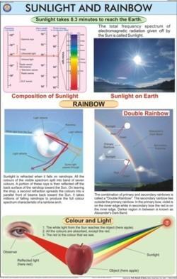
Laminated Paper Sunlight & Rainbow Colours Chart
MOQ - 1
Material - Laminated Paper
Color - Multi colours
22 Years
Business Type: Manufacturer | Exporter
N. C. KANSIL & SONS
Made in India

Geography Lab Catalog Application: Research
Price: 300 INR (Approx.)/Piece
MOQ - 1 Piece/Pieces
Color - White
Usage - Educational use
Product Type - Geography Lab Catalog
Business Type: Exporter | Trading Company
RX2 SCI-TECH INDIA
The Sun & Planets (Solar System) Chart Dimensions: 70 X 100 Centimeter (Cm)
Price: 275 INR (Approx.)/Piece
MOQ - 25 Piece/Pieces
Material - Laminated
Dimensions - 70 x 100 Centimeter (cm)
Shape - Multicolour
Business Type: Manufacturer | Supplier
VIDYA CHITR PRAKASHAN
Geographical Model
Price: 10000 INR (Approx.)/Piece
MOQ - 1 Piece/Pieces
Business Type: Manufacturer | Exporter
SENCO INSTRUMENTS

3 Years
Business Type: Manufacturer | Exporter
FAIZ ENTERPRISES
4 Years
Business Type: Manufacturer | Distributor
ACE
Business Type: Manufacturer | Distributor
Success Paper Products
Business Type: Manufacturer | Distributor
SHAW ENTERPRISE
Indian Inquiries Only
Business Type: Service Provider
MULTIMIND CREATIONS
Indian Inquiries Only
Related Searches
Business Type: Manufacturer | Exporter
NAUGRA EXPORT
Business Type: Distributor
Allen Scientific Traders
Business Type: Manufacturer | Distributor
NANDA CHITRA PRAKASHAN
Business Type: Manufacturer | Exporter
TINNY EDUCATIONAL AIDS
Business Type: Manufacturer | Exporter
LAB SECTION
Business Type: Exporter
NCBA EXPORTS PVT. LTD.
Geographical charts are detailed maps of a particular area, the term "area" here encompasses all water bodies, land, atmosphere etc. Geographical charts are widely used for navigation purposes in ships, flights and by people who are out there to explore a certain geography and many more.
Geographical charts are designed in such a way so as to ensure these are easy to read and understand. Also, a greater care is accorded to make sure the proportional distances relative to the real distances are as precise as possible. It would also be safe to assume that these charts are an essential part of scientific research, oceanography, astronomy and many other sectors.
As mentioned above, geographical charts are of different types with various specifications; these are affordable and can be customized to some extent.
Benefits of Geographical Charts
Geographical charts provide a wide range of information that makes these useful to both professional as well as recreational chart users. Some benefits accorded by these charts are,
These help in planning of the route to be taken while reaching a destination
These provide accurate latitude and longitude figures
Detailed geographical charts also allow a navigator to give a sense of where he/she is vis-a-vis the international date line, thus enabling accurate time keeping
In case of any unforeseen situation, these can also help users reach the nearby safety and evacuation point
Geographical charts relating to astronomy have wide usage in calculating distances between different planets, stars etc.
How to Correctly Read a Geographical Chart
To optimally utilize a geographical chart, one needs to take care of the following aspects :
Choose the right chart i.e- the chart should conform to the geography of the place where one is hoping to utilize it.
To read a chart correctly one needs to understand compass directions, grid references and the map's key and scale.
Check the chart's orientation, most charts contain maps that are drawn with north located at the top.
Understand the scale of the chart. If the scale is 1:1000, then simply put, 1 unit in the chart is equal to 1000 units in real world.
Note the latitude and longitude.
Learn how to read contour lines. Contour lines indicate how high or flat the land area is.
Figure out the starting point and the destination on the chart before embarking on a journey and also plot the full route.
Client Testimonials & Reviews
Geographical Chart Price List
This Data was Last Updated on 2024-04-25
Geographical Chart Manufacturers | Suppliers in India
| Company Name | Location | Member Since |
|---|---|---|
| N. C. Kansil & Sons | New Delhi, India | 22 Years |
| Labcare Instruments & International Services | Ambala Cantt, India | 6 Years |
| Ace | Mumbai, India | 4 Years |
| Faiz Enterprises | Ghaziabad, India | 3 Years |
FAQs Related to Geographical Chart
- N. C. Kansil & Sons
- Labcare Instruments & International Services
- Ace
- Faiz Enterprises
- Delhi
- Pune
- Kolkata
- Ambala
| Company Name | Currency | Product Name | Price |
|---|---|---|---|
| LABCARE INSTRUMENTS & INTERNATIONAL SERVICES | INR | Geography lab Equipment | 99 |
| VIDYA CHITR PRAKASHAN | INR | Mountain Building Chart | 275 |
- N. C. KANSIL & SONS
- RX2 SCI-TECH INDIA
- LABCARE INSTRUMENTS & INTERNATIONAL SERVICES
- LAB SECTION
Related Categories
- Tradeindia
- Educational Aids
- Geographical Chart